We’ve struck water!
We are delighted to share that the first phase of our borehole project has been successfully completed! After drilling 256m, we have finally hit water!
Here’s the video of this exciting, milestone moment:
The Impact
Thanks to the incredible support of our donors, Reteti now has the beginnings of reliable and permanent water source for the orphaned elephants, despite the harsh impacts of climate change in Northern Kenya.
This water source will also allow us to re-wild the orphans directly from the sanctuary and into Namunyak Conservancy. The water will draw wild elephants in which will allow for the orphans to have daily interactions with their wild counterparts, eventually leading to their gradual integration into the wild with new herds or as an orphan herd.

Our Next Steps
A 2-litre sample of water from the borehole is currently at a laboratory for a full physical, chemical and bacteriological analysis before the water is put to any use.
We’re also going to “elephant-proof” the borehole and the pipeline - a somewhat entertaining conversation since the water is for the elephants. Fortunately, the drillers are experienced with elephant proofing boreholes in remote wilderness areas and presented a great solution.
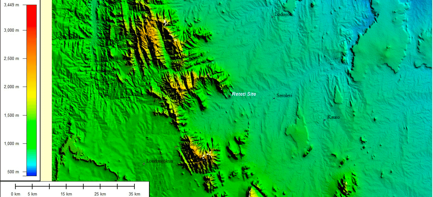
AN EXCERPT FROM THE HYDROGEOLOGICAL SURVEY REPORT
Reteti is located at the edge of the Matthew Range, which follows the N-S orientation of the Mozambican Orogenic Belt. To the east, there are a few volcanic outcrops. Regional topography is well captured in the map below.
The crystalline rocks of the Basement Complex that are present in the area are relatively impermeable and, in their fresh state, form poor aquifers. However, where these rocks have been exposed to the elements and where weathering has occurred, the breakdown of the minerals that form the rock may lead to the formation of conditions favourable to the storage of water. This is usually referred to as "deep weathering".
Fractures, cracks, folding and faulting resulting from regional upheavals all enhance the capacity of metamorphic rocks to store groundwater.
The occurrence of shallow groundwater in Basement rock is limited to areas where the regolith, the weathered and decomposed upper portion, is sufficiently thick to form substantial storage.
The term "river aquifer" can be used to define sand rivers (called "luggas" in Samburu) which contain and carry groundwater. In arid areas such as Northern Kenya, such rivers are dry for several months of the year due to the lack of precipitation. However, during the rainy season most of these luggas will carry runoff.
Since the luggas flow over rock, vertical loss of water from the river can take place, especially if the bedrock is fractured. There will thus be a rise in the regional groundwater level in the rocks along the axis of the lugga. Suitable borehole sites to tap the deeper groundwater will thus be found in the vicinity of the luggas where fractures in the bedrock occur.
This project simply wouldn’t have happened without the generous support of our donors.
THANK YOU!